Apollonia-Arsuf Excavation Project
Directed by: Prof. Oren Tal
Apollonia-Arsuf is located in the northwestern part of the modern city of Herzliya on a kurkar (fossilized dune sandstone) ridge overlooking the Mediterranean shore (Fig. 1). The site lies 17 km north of Jaffa (Joppa) and 34 km south of Caesarea. The ground of the eastern part of the site rises 35 m above sea level, and from there gently slopes down to the west, to about 20 m above sea level (Fig. 2).
Fig. 2 – site plan
The first systematic excavations at Apollonia-Arsuf were carried out in 1950, north of the medieval town wall, on behalf of the Israel Department of Antiquities and Museums, first by I. Ben-Dor and then by P. Kahane. These salvage excavations were carried out in the context of the establishment of an Israel Defense Forces (IDF) factory that occupied a great part of the site, albeit leaving its western area relatively unharmed. Ben-Dor excavated several trial trenches down to virgin soil, from which he ascertained that this part of the site had never served as a residential area. He uncovered a series of three different types of winepresses, indicating that the site had served as an industrial quarter of the Byzantine town. Kahane worked on a larger scale, throughout the entire area, in six different locations, three of which revealed substantial architectural remains. His main discoveries comprised three types of structures belonging to three different periods: Late Roman tombs, Early Byzantine oil presses, and Late Byzantine/Early Islamic raw glass furnaces. Unfortunately, the exact locations of the excavated areas of the 1950 season remain largely unknown. In 1962 and 1976, following development works in the IDF factory area, a polychrome mosaic floor and several bases of columns, located along an east-west line, were uncovered (Area K), all belonging to a Byzantine church.
The first large-scale excavations at Apollonia-Arsuf were carried out in 1976–1977 by I. Roll, who directed 18 seasons of excavations at the site, with the last one in 2006. The 1976–1977 season was a salvage excavation on behalf of the Israel Department of Antiquities and Museums (within the IDF factory area), and it was only in 1982 that the excavations (outside the IDF factory area) became an academic project of Tel Aviv University’s Institute of Archaeology. The 1996 season was a contract excavation, initiated by the legal owner of the entire area of Apollonia-Arsuf at the time – the Israel Lands Authority, and was carried out in the area of the IDF factory, prior to its planned evacuation. The request was to undertake a series of trial excavations, extending from the Crusader town-gate (Area J) to the east, with the purpose of determining the maximum extension of the ancient site and defining its eastern limits.
The 1998, 1999, and 2000 seasons of excavations were organized as a joint venture between Tel Aviv University’s Institute of Archaeology and the Universidade Federal do Rio Grande do Sul of Porto Alegre, Brazil, with the financial backing of the Municipality of Herzliya and the Israel Nature and Parks Authority.
In 2001 the site of Apollonia-Arsuf became a national park, and in 2004 it was formally recognized by the World Monuments Fund as one of the 100 most endangered world monuments. In 2006 it was included in the tentative list of world heritage Crusader castles by UNESCO; and in 2007 it became the case-study of a National Science Foundation grant, titled “III-CXT-Core Large: Computer Vision Research: Promoting Paradigm Shifts in Archaeology” (Grant #0808718). All these occurrences emphasize the importance of continuing archaeological excavations and conservation of the site (Fig. 3).
Fig. 3 – Crusader castle, looking northeast
In 2006 an 18th season of excavations was carried out in conjunction with the Artemis and Martha Sharp Joukowsky Institute for Archaeology and the Ancient World, at Brown University. This season saw a transition during which the directorship and responsibility for the future excavations at Apollonia-Arsuf were transferred from I. Roll to O. Tal. In 2009 a 19th season of excavations took place at the site. This was the fruit of a collaboration between Tel Aviv University’s Institute of Archaeology and Brown University’s Division of Engineering researchers (headed by David B. Cooper), partially funded by the National Science Foundation. The Brown University researchers were responsible for computerized vision research (digital archaeology), documenting the site excavations and its archaeological remains, with the aim of shifting the previous paradigm of archaeological site documentation in order to promote archaeological research in Israe and beyond.
While the 2010 (the 20th) season ran independently, excavations at the site (the Apollonia National Park) from the 2012 to 2016 (the 21st to the 25th) seasons of excavations were the fruit of a collaboration between Tel Aviv University and the University of Tübingen (Germany) (headed by Prof. Dr. Barbara Scholkmann), partially funded by the Deutsche Forschungsgemeinschaft (DFG), with the aim of investigating “The Crusader Town of Apollonia / Arsur (Israel): Structure – Cultural Adaptation – Urban-Rural Relations”. This joint project sought to achieve a better understanding of the European and local cultural influences that had dictated the structure and organization of the town of Arsur and its hinterland. The town’s abandonment following the Mamluk destruction led to a unique archaeological setting in which the Crusader layers have been left largely undisturbed by later settlement activities, and thus are highly conducive to in-depth archaeological research. These layers have been the focus of extensive light detection and ranging (LiDaR) analysis as well as geo-magnetic surveys, enabling a reconstruction of the original topography and design of the entire medieval town through detection of the layout of structures still concealed from sight below the ground. The finds from the latter excavations complete the picture acquired through the surveys, enabling insights into the material culture and daily-life activities of the town’s inhabitants.
The 2012, 2013, and 2017 (the 21st, 22nd, and 26th) seasons of excavations were also salvage excavations, initiated by the owner of the site’s eastern outskirts, the Israel Lands Authority. In a series of trial and rescue excavations in the area extending from beyond the deserted IDF factory to the coastal highway (Road No. 2), we examined the site’s immediate hinterland and its character, in the face of future possible construction developments in the area.
The 2018, 2019, and 2020 (the 27th, 28th, and 29th) seasons of excavations ran independently, concentrating on the Crusader castle’s western façade, as the focus of an Israel Science Foundation (ISF) Personal Research Grant (No. 2050/17), titled “Contextualizing the Architectural Language of the Military Orders: Reconstructing the Frankish Castle of Arsur in Light of its Recently Discovered Chapel”. The 2022 (the 30th) and the 2023 (the 31st) season of excavations also ran independently as a continuation of the previous three seasons, now with the financial support of the Israel Nature and Parks Authority.
PERIODS OF OCCUPATION (AS UNCOVERED DURING THE PRE-2006 SEASONS OF EXCAVATIONS)
The site of Apollonia-Arsuf was occupied as early as the Chalcolithic period and Iron Age II, but it is in the context of the Persian period that Apollonia-Arsuf became a coastal urban center, under Sidonian hegemony. We learn from the tomb inscription of Eshmun‘azor IInd, King of Sidon in the late 6th century BCE, that the Persian (Achaemenid) king had granted him Dor and Joppa, the mighty lands of grains on the Sharon plain. This statement implies that the entire geographical unit of the Sharon plain was in Sidonian hands, most probably as tribute for the participation of King Eshmun‘azor’s fleet during the first Persian military campaigns in Egypt. Another historical reference that indicates the site’s administrative status is that by Periplus of Pseudo-Scylax (mid-4th century BCE), who states that both Dor and (apparently) Joppa are under Sidonian suzerainty. It thus seems that throughout its existence under Achaemenid rule Apollonia-Arsuf was under the rule of the Province of Dor. Being the main town and haven of the southern Sharon plain it became the chief commercial and probably also industrial center of the region. The town’s inhabitants, the Phoenicians, left their linguistic mark on the town by naming it after one of their gods, Resheph. Even though the town’s Phoenician name does not appear to have been attested to in writing, and its conquerors and foreign inhabitants soon renamed it, it was nonetheless not forgotten for, at some later point, the Arabs reinstated the Semitic name, “Arsuf”, which may suggest that in Persian times the site was called “Arshoph”. The settlement in Persian times is represented by two strata over an area of less than 20 dunams. These strata contain minor architectural remains, presumably domestic in nature, in Area H, and a large refuse pit in Area D. The finds, ranging in date from the late 6th to the late 4th century BCE, comprise mostly common pottery but also imported wares, fragments of male and female terracotta figurines, and a fairly large number of Sidonian coins. A unique discovery is that of a 4th-century BCE Pentelik marble relief (11 x 15 cm) of the Totenmahl (funerary banquet) type (Fig. 4). The scene depicts a bearded man in frontal view, dressed in a mantle and reclining on a couch (klinē). In his right hand is an elongated object, probably a rhyton, while his left hand holds another object, which may be a phiale. Opposite the man, seated on the left end of the couch, is a woman in profile with her hair bound in a sakkos, wearing a chiton and resting her feet on a footstool. In her left hand is a cup-like object, while her right hand seems to be resting on her thigh. Behind the woman, two smaller figures – a bearded male and a veiled female – both wearing a chiton, stand in profile facing the reclining man, with their hands raised as if in worship. At the top left corner is a bust of a horse within a frame. In the lower right corner, the lower part of a krater is visible, next to an offering table with turned legs. Underneath the table, a coiled serpent stretches towards the reclining man. To the left of the table is a pedestal-like altar, whose presence at Apollonia-Arsuf should be attributed to the connections of the town to the Greek world (especially Attica), as also demonstrated by other archaeological finds retrieved from the site. The relief’s connection with the cult of a hero or an heroized deceased mortal strongly suggests the presence of Greek individuals having practiced such a cult at the site. Whether this dead hero was buried at the site or in his homeland is impossible to determine, although one cannot exclude the possible presence of a Greek family who had settled at the site and buried and commemorated one of its members there.
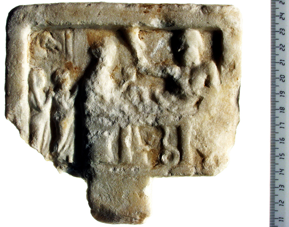
Fig. 4 – Totenmahlrelief
It was during the Hellenistic period that the site was renamed Apollonia. We have evidence that the Phoenician god Reshef was already being identified with the Greek god Apollo as early as the 4th century BCE. It is thus not surprising to learn that the site was influenced by the region’s Hellenization or, rather, lingual revolution: Arshoph became Apollonia, Dor became Dora, and Joppa became Ioppe. Archaeologically, the size of the settlement remained that of the Persian period and is represented by a single stratum with minor architectural remains in Area H and a refuse pit in Area D. The finds, ranging in date from the late 4th to the late 2nd century BCE, mostly comprise common pottery but also some imported wares and stamped amphora handles. All the finds indicate that the site was abandoned in Early Hasmonean times, apparently within the framework of Alexander Jannaeus’ territorial expansions in the Sharon plain. The poor preservation of both the Persian and Hellenistic strata at the site is due to the intensive building activities that took place in later periods.
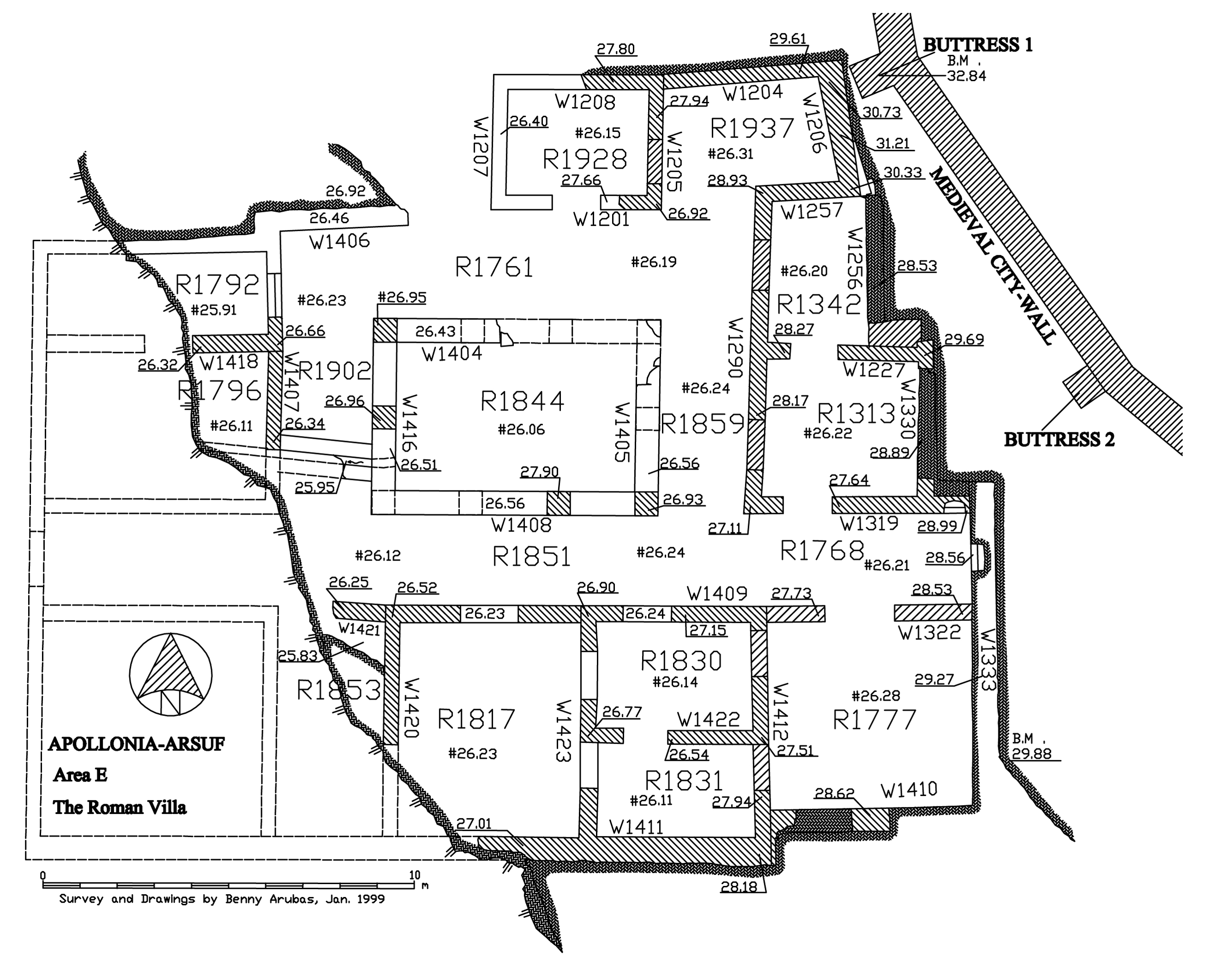
It is in the Roman period that the site is first mentioned in the historical sources. Flavius Josephus lists Apollonia among the cities belonging to the Jews under the rule of Alexander Jannaeus, together with Joppa. Pliny and Ptolemy list Apollonia among the coastal cities of Iudaea-Palaestina. The depiction of Apollonia on the Peutinger map along the coastal highway, between Joppa and Caesarea, indicates that it served as an official section of the country’s Roman imperial road network. The most significant remains of the Roman period occupation at the site are undoubtedly those of a typical Roman villa of the peristyle type uncovered in Area E at the southern part of the site. Located adjacent to the southern flank of the Early Islamic town wall, the villa was built on a platform hewn from the natural sandstone rock. Measuring ca. 21.5 x 24 m, the building was laid out in the precise directions of the four cardinal points of the compass. As the western façade of the dwelling faces the sea, it seems clear that this was a villa literalism-type building, which could have perhaps functioned as a mansio on the Roman coastal road network (Fig. 5).
|
Fig. 5 – The Roman villa (Area E), aerial view (on left) and plan (on right) |
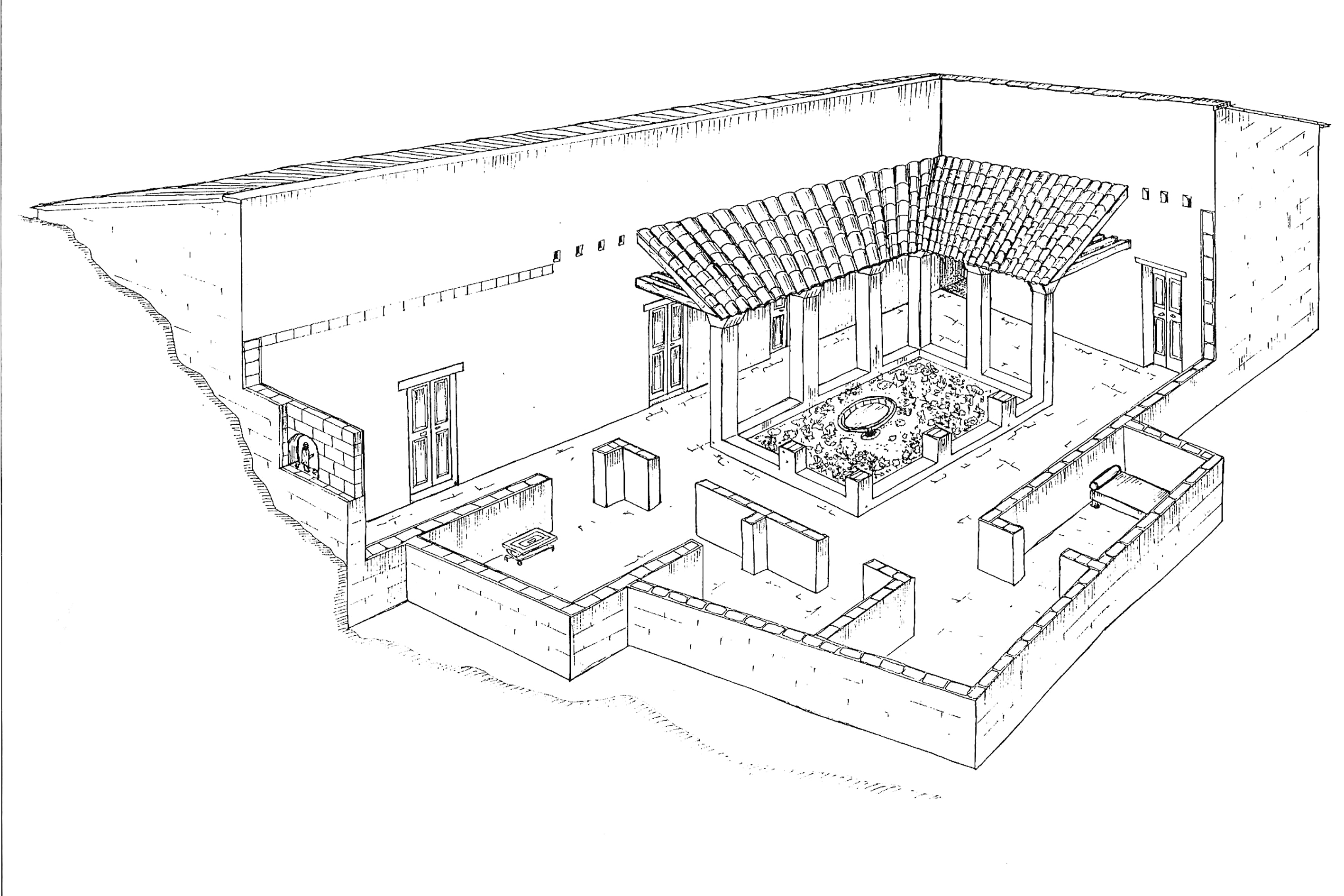
Fig. 6 – Artistic reconstruction of the Roman villa
A peristyle courtyard occupies the center of the building, surrounded by square piers supported by a stylobate. To its south is a long corridor that crosses the entire building from west to east. In the upper parts of two of the walls at the eastern end of the corridor are plastered niches that recall the lararia of the typical Italian dwelling. Three shorter corridors surround the other three sides of the courtyard. The walls of the villa were remarkably well built, with large kurkar ashlars set into gray cement, which was the typical construction method of the Roman period (Fig. 6). Overall, the structure was built according to the standard of the Latin foot (pes), which measures ca. 0.3 m. The thickness of the inner walls, with the exception of the walls of the peristyle, ranges between 0.4 and 0.45 m, corresponding to one cubitus (0.45 m).The central courtyard, with interior dimensions of ca. 6.45 x 3.85 m, corresponds to 22 x 13 pedes; and the corridors measure 2.4 m on average, corresponding to 8 pedes. The interior dimensions of the rooms also seem to correspond on the whole to the standard of the Latin foot.
This structure, previously unknown in the building tradition of Iudaea, clearly reflects an aspect of the Romanization of the coastal plain of Judaea that was apparent in the late 1st century CE. In a later phase of the villa’s use, the entrances to several rooms were intentionally and rather carelessly blocked, perhaps indicating that several of the living rooms had been turned into storage rooms for the villa’s more modest dwellers. The entire complex then suffered a sudden and violent destruction, probably caused by a devastating earthquake in 113/114 or 127/128 CE.
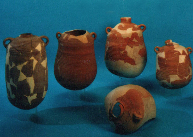
Most of the finds from the villa come from the later phase and include tableware, cooking and storage vessels, and local and imported lamps (Fig. 7). Smaller quantities of stone and glass vessels, bone objects, and human and animal figurines were also discovered.
 |
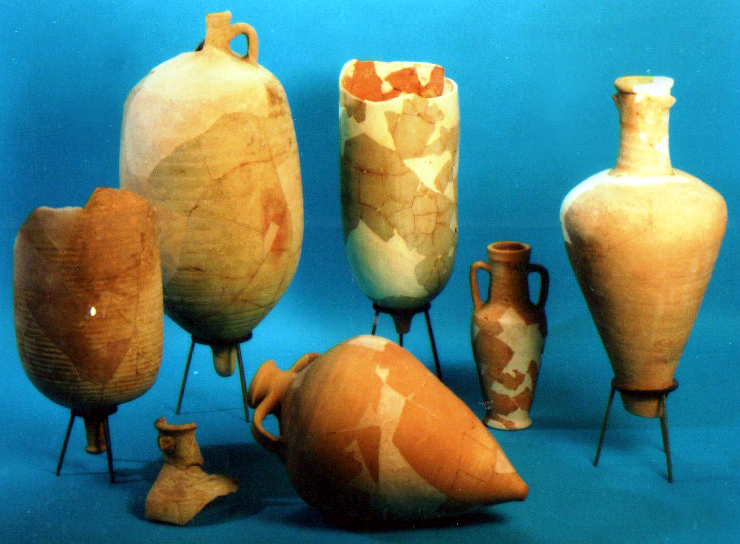 |
Fig. 7 – Selection of pottery vessels from the Roman villa later phase
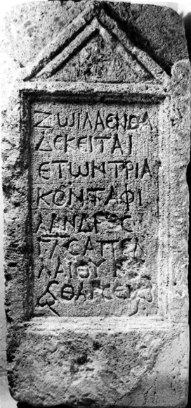 |
Fig. 8, left – Gravestone of Zoila; Fig. 9, right – Greek inscription on the church’s mosaic floor (Area K)
Another important Roman find was a gravestone with a Greek inscription. It has a rectangular frame, surmounted by a pediment with acroteria at the corners and a rosette inside the tympanum. The inscription can be translated as follows: “Here lies Zoila, thirty years of age, who loved her husband. (Died in the year) 233, 26 of Apellaios. Courage” (Fig. 8). As noted previously, Flavius Josephus mentions Apollonia as one of the cities inhabited anew at the order of Gabinius, and the year 233 apparently refers to the Gabinian era, which began in 57 BCE, indicating 176 CE as the probable date of this inscription.
A polychrome mosaic floor and several column bases placed along an east-west line were uncovered in 1962 and 1976 in Area K. These elements belonged to a Byzantine church, of which only a part of the nave has survived. The preserved part of the floor is decorated with stylized geometric and floral patterns, framed interwoven motifs, and birds inside round intertwined medallions. The most impressive part of the mosaic floor is a three-line Greek inscription framed in a tabula ansata, intended to be read when facing east. The inscription is partly damaged but the following reading is suggested: “I am a church better than ambrosia and nectar, and Marinos erected me exalting God-extolled-for-His wisdom and ever ruling His pure and mystic spirit” (Fig. 9).
The inscription is in dactylic-hexameter verse and of a clear poetic character. Its metaphoric language was meant to make a declaration – ostensibly by the church itself – that it had been built by one Marinos who was well acquainted with Classical Greek culture. Moreover, the words “ambrosia” and “nectar” point to a tradition reminiscent of the highest achievement of Greek literature: the Homeric epic. However, the inscription also very clearly emphasizes the superiority of the Christian Church over the Classical tradition, due to the Church’s ruling wisdom, pure nature, and mystic spirituality. The decorative pattern of the compound and its inscription indicate a 5th–6th century CE date. This church may have served as the seat of the Bishops of Sozousa (Byzantine Apollonia).
Other architectural remains attributed to the Byzantine period primarily comprise a series of industrial installations, such as water cisterns, wine- and oil-presses, primary glass kilns, and other remains of unclear function. The primary glass kilns, or furnaces, deserve special attention due to the rarity of such finds. Two glass furnaces were reported to have been excavated as early as 1950 by Kahane, and were attributed an Early Islamic date; another glass furnace was discovered during the 2002 season in Area N (Fig. 10); and the remains of additional furnaces were discovered in Area O during the 2009 season and in Area N1 in 2017 (see below). The Area N furnace is an isolated ashlar-built structure consisting in two parts: a melting chamber (ca. 5.0 m x 3.8 m); and a firing area (ca. 3.8 m x 1.6 m), with two conical-shaped firing chambers that opened onto the melting chamber. A large glass slab (ca. 4.45 x 2.95 m) was found on the melting chamber floor, which was separated from the firing area by a segmented stone wall. Extracting the slab would have required the roof of the installation to be dismantled after the glass had solidified and cooled. This would have been done by hammering and removing chunks of various sizes, as reflected in the dents created on the preserved remains. The entire installation was overlain with fired mud-bricks. The high-quality raw glass that was extracted was transparent-blue and greenish-blue with a few bubbles; whereas the glass from the preserved northwestern and southeastern corners of the melting chamber was yellowish-green and yellowish-brown, resulting from the lower amount of oxygen it had absorbed (a high oxygen level leaves a bluish-greenish tinge and a low oxygen level leaves a yellowish tinge). Numerous chunks of raw glass were discovered during the excavations. We can assume that chunks of insufficient weight or size for trade were discarded and were probably removed from the slab during its extraction. Under the glass furnace we also found a few pottery body fragments from a well-known type of Palestinian bag-shaped jar of Late Byzantine date. The firing chambers in the glass furnace from Apollonia-Arsuf were located on the west side of the installation and the melting chamber on the east. The two firing chambers facing west were open to the sea winds, thus facilitating the airflow that otherwise would have required the use of bellows. The roof of the melting chamber was probably vaulted, with a few openings (or chimneys) to provide better air circulation. In the Late Byzantine period the “crater” stretching between Areas E and M was one of the main waste dumps inside the town of Sozousa. Around 10 tons of Late Byzantine pottery were retrieved in the excavations of Area E and an additional 13 tons were sorted from Area M during the 2006 season alone! The pottery, glass, metal, and stone vessels and objects reflect the inhabitants’ daily use of such items. There are also several graves belonging to the Byzantine period in the immediate environs of the site, notable among which are the built cist tombs, which were found undisturbed alongside a damaged mausoleum.
Fig. 10 – Glass furnace (top) and chunks of raw glass (bottom) (Area N)
Following is a list of other important Byzantine finds discovered at the site during the 1880s:
-
A marble statue of a standing eagle with contracted wings, with a monogram that reads ΙΟΥΛΙΑΝΟΣ, apparently referring to the Byzantine Emperor Julian (361–363 CE).
-
A fragment of a marble relief showing the lower part of two of a horse’s legs. This iconographic document, albeit fragmentary, is of great importance in being directly related to the contentious issue of when and where the common use of horseshoes began.
-
A wide limestone lintel of a tomb bearing a Greek inscription that reads “One is the living God. Babas (son) of Maximus, grandson of Kosmas, made the burial monument for Marcellina Justina.”
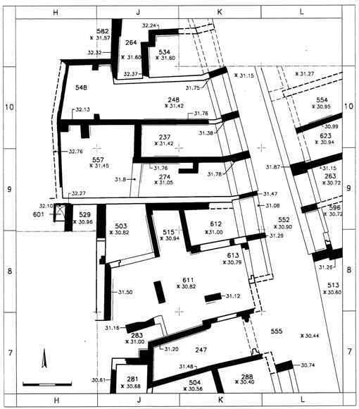
The historical documentation of Early Islamic Arsuf is supported by several archaeological finds. Long stretches of the town wall were uncovered in the southern and western parts of the site (Areas E and H); and the earliest finds, unearthed in the inner rooms adjoining the walls on the interior, date to the reign of the Ummayyad Caliph ‘Abd el-Malik (685–705 CE). The initial phase of a market street, of which a section of ca. 65 m has been uncovered, was exposed in the eastern part of the site (Areas B and C) (Fig. 11).
|
Fig. 11 – Early Islamic market (Areas B and C), plan (on left), artistic reconstruction (on right) |
Various buildings flanking both sides of the street, and which had served as shops and food-stalls, date to the same period. These finds indicate that Early Islamic Arsuf became a fortified town, with a large part of it having been rebuilt according to a comprehensive urban plan already at this early stage.
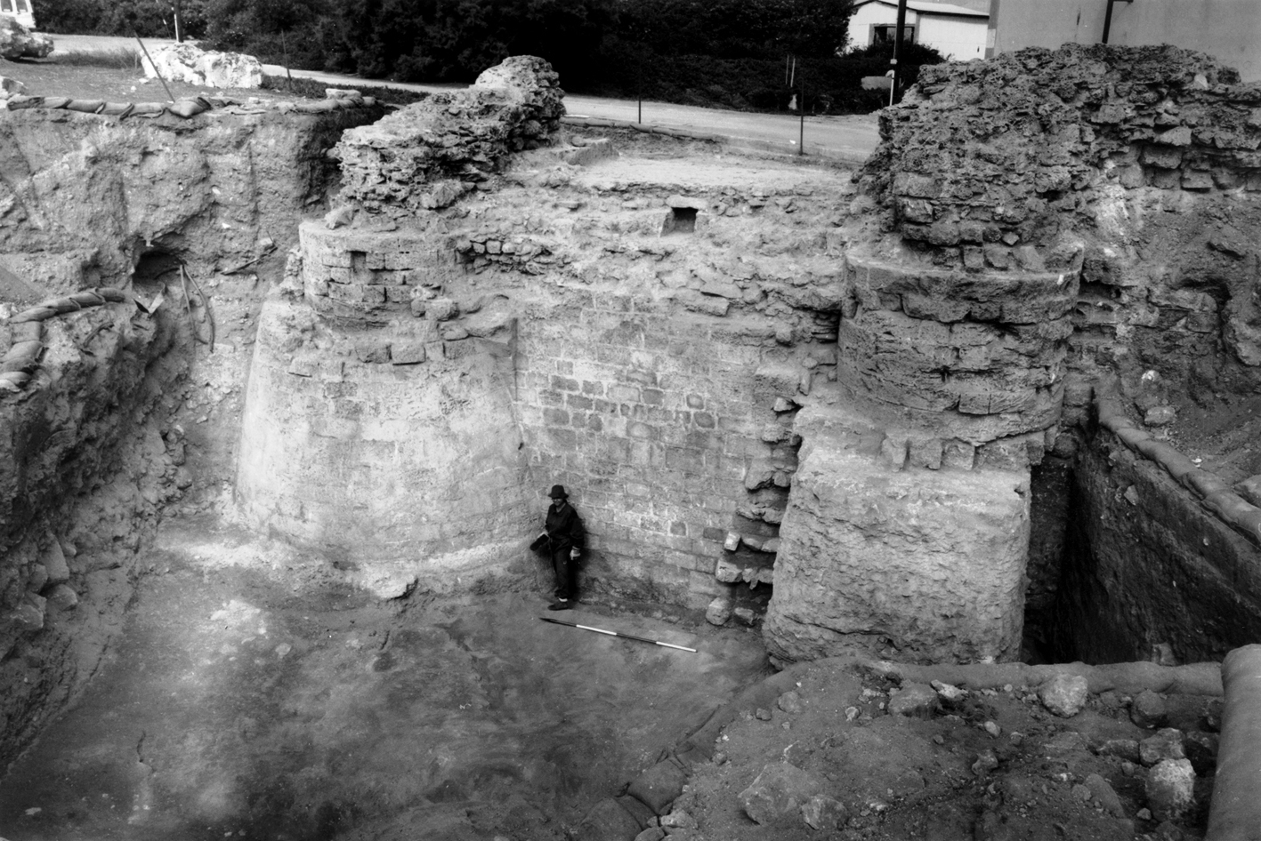
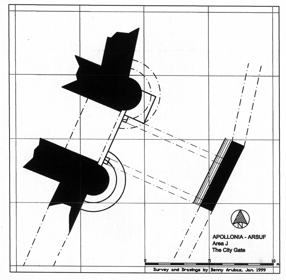
Excavation of the Crusader town-gate (Area J) revealed two construction phases, both from the Crusader period (Fig. 12).
|
Fig. 12 – Crusader town-gate (Area J), photo (on left), plan (on right) |
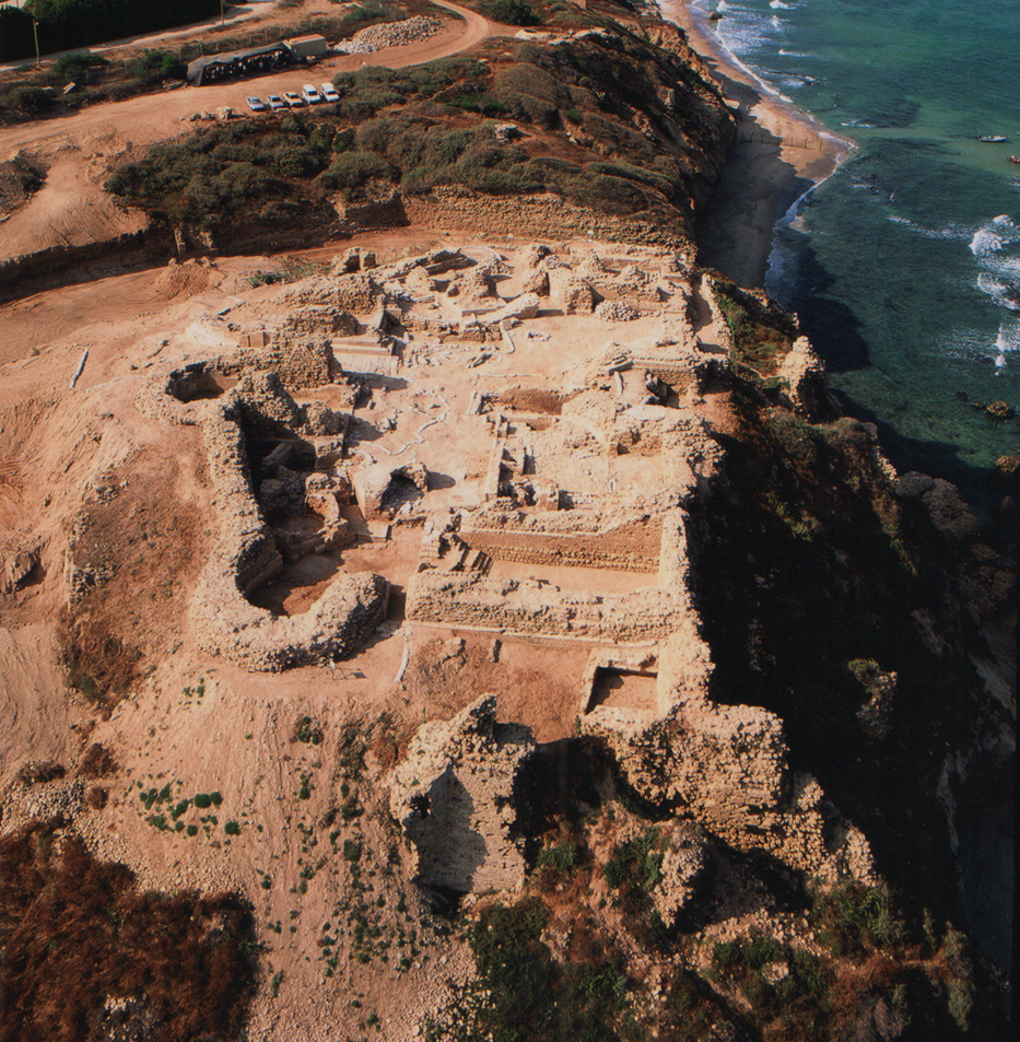
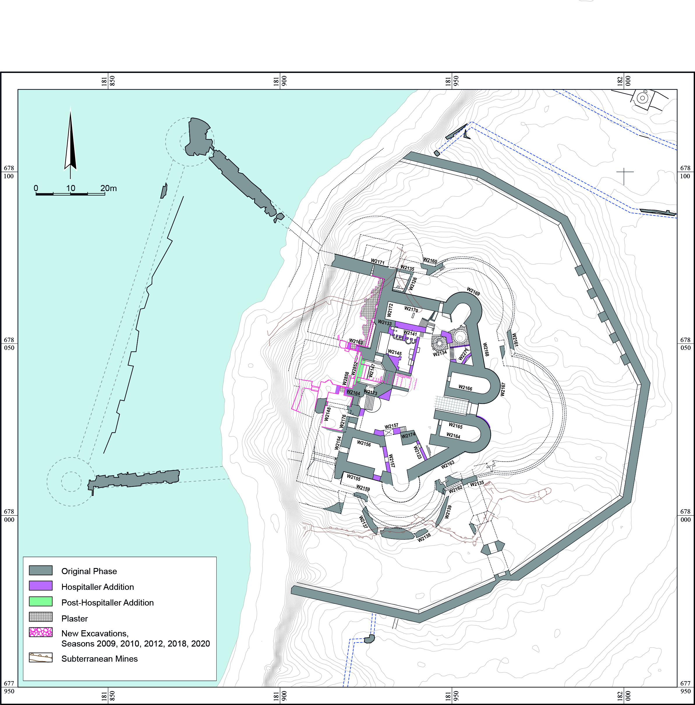
Large-scale excavations were conducted in the Crusader castle (Area F), exposing almost all the components of the castle’s latest phase (Fig. 13). These include the following elements, described from the center outwards: (1) a central irregular courtyard surrounded by broad halls; (2) the main pentagonal fortification complex, including a gate protected by two semicircular towers with an additional semicircular tower on each side in the east, and a donjon and two square corner towers in the west; (3) an external fortification with a contour corresponding largely to that of the main fortification but at a lower elevation and with a wider opening; (4) a broad, deep moat bounded by an outer retaining wall; (5) a system of vaulted halls and retaining walls along the cliff on the western façade of the castle, which had largely collapsed to the base of the ridge; and (6) an anchorage facility, of which the foundations of the northern and southern breakwaters have been preserved.
|
Fig. 13 – Crusader castle (Area F), photo (on left), plan (on right) |
 |
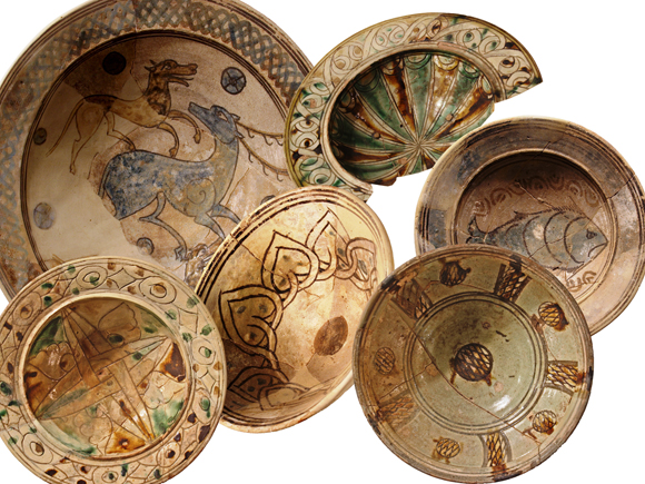 |
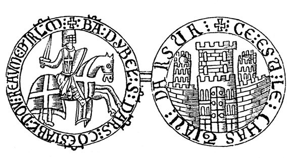
Fig. 14, left – Balian’s seal; Fig. 15, right – Selection of glazed bowls from the Crusader refuse pit (Area F)
A particularly unique find published by the Italian scholar S. Paoli in 1733 is that of the official seal of Balian of Ibelin’s short lordship of Arsur (1258–1261 CE).The seal was found in Malta. Its reproduction shows (Fig. 14) a fully armored knight brandishing his sword and galloping to the right on a caparisoned horse. The surrounding inscription reads: “Ba(lian) d’Ybel(in) s(eigneur) d’Ars(ur) co(n)establ(e) dou reaume d(e) I(e)r(usa)l(e)m” (= “Balian of Ibelin, Lord of Arsur, Constable of the Kingdom of Jerusalem”). The other side depicts a castle with crenellated fortifications, as well as two corner towers and a gate dominated by a central donjon. The inscription around it reads: “Ce est le chastiau d(‘)Arsur” (= “This is the Castle of Arsur”). The reproduced document, though schematic, provides a unique iconographical representation of the Lord of Arsur and his castle. In mid-March 1265 CE a large and well-prepared Muslim army under the personal command of Baybars laid siege to Arsur. From the Crusader point of view, Arsur was relatively well prepared. Its town and castle were strongly fortified, well-provisioned, and defended by some 2,000 warriors, of whom about 270 were Brothers of the Hospitaller Order. Excavations show that during the Mamluk siege, tons of soil were intentionally piled against the interior walls of the Crusader town fortifications, and buildings adjoining these fortifications were packed with soil in order to strengthen them. A stone and cement foundation (3 m wide and 17 m long) found in Area P seems to have been built at that time and may have been used to convey ballista machinery. On April 26, 1265 CE, after forty days of siege, a concerted attack was carried out and the town was taken by storm. The surviving defenders took refuge in the castle and continued to fight with superb courage. However, after three more days of fierce fighting, Muslim warriors took control of part of the castle’s fortifications and raised the banners of Islam over the walls. The Hospitallers, having lost up to 1,000 warriors, including 90 knights, negotiated their surrender on the condition that the survivors would be free to leave. Baybars at first agreed but then broke his word and all the Christian prisoners were taken into slavery. Moreover, he forced them to participate in the systematic demolition of their own stronghold. The entire site of Arsur was razed to the ground and left in ruins. This final destruction is largely attested to by the thick conflagration layers and ruins that have been uncovered in the excavated areas throughout the fortified site in general, and in the castle in particular. A unique discovery found in the Crusader castle is that of the refuse pit of the besieged inhabitants, which contained numerous local and imported pottery vessels (Fig. 15), plain and luxury glass vessels, and metal and stone artifacts. The importance of this assemblage lies in its absolute dating: March-April 1265 CE.
ADDITIONAL RECENT (MAIN) DISCOVERIES (POST-2006 SEASONS OF EXCAVATIONS)
One of our main discoveries came from Area O in the northern part of the site (in the 2006 and especially the 2009 seasons), where a large mosaic floor winepress (9.8 x 7.5 m) was uncovered, with a Greek inscription in the center of the treading floor. The inscription reads: “One only god, help / Cassianos together with (his) wife / and children and everyone.” The inscription’s formula, together with the finds we discovered during excavations in the area, point to Samaritan ownership of the complex in Byzantine times (5th–6th century CE) (Fig. 16). Such dedicatory inscriptions are mostly known from Samaritan cult buildings (synagogues); and it is possible that the winepress may have formed part of a larger structure of a public nature associated with cultic activity. The winepress settling (fermentation) pit (ca. 2.9 m in diameter and 2.35 m deep) is among the largest ever discovered in Israel. Based on the archaeological evidence, the winepress had ceased to function sometime during the first half of the 6th century CE (possibly in relation to the Samaritan revolt [529 CE]). The abandoned winepress was later damaged by an earthquake (apparently that of 749 CE). The winepress complex area was covered in the dismantled remains of raw glass furnaces supplemented by an archaeological layer of raw glass production debris. It appears that following abandonment of the Samaritan-owned viniculture industry in the area, it was occupied by the site’s Christian inhabitants, who we believe were engaged in the production and trade of raw glass under the auspices of the Church.
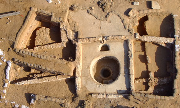
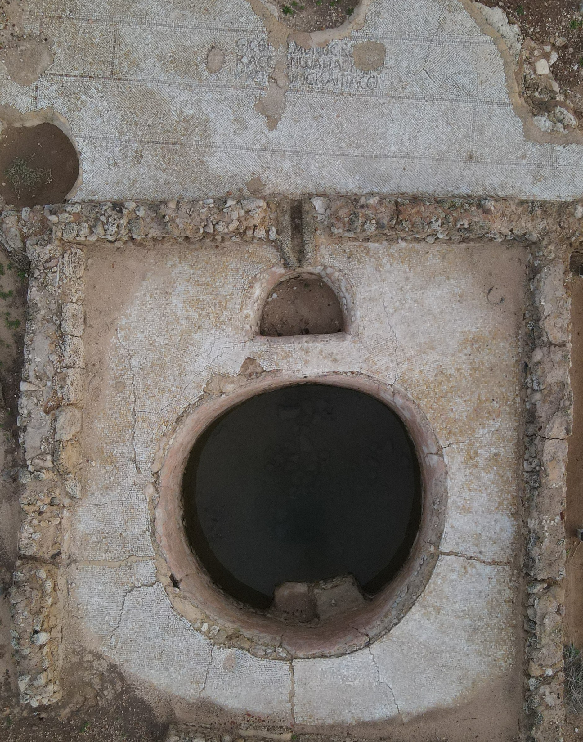
Fig. 16 – A Samaritan winepress (Area O)
In the Crusader castle (Area F), which is the prominent architectural complex of the site, the 2009, 2010, 2012, 2018–2020, and 2022 excavation seasons were focused on the western part of the castle on top of the coastal cliff, seeking to expose the subterranean complexes and remove part of the dirt load from the cliff in order to facilitate future arrangements for a better rainfall drainage (Fig. 17). The excavations uncovered parts of the castle’s western façade and a series of subterranean halls aligned along a north–south axis. In the northern hall we uncovered a stable with a plastered stone shelf along its eastern wall (ca. 8 m long, 0.8 m high and 0.4 m thick), incorporating rock-cut tethering-stones and the remains of plastered troughs on top of the shelf. The central hall, enabled access to the northern and southern halls. It also enabled access to an outer ramp that led to the seashore via an opening in its southwestern corner, whose marble threshold was unearthed. The central hall constitutes the area above which the castle chapel had probably existed (Fig. 18). The southern hall still remains to be fully cleared of the debris from the fallen donjon and other building remains. Evidence of a post-destruction (1265 CE) occupation (Mamluk, World War I) in this area of the castle is already apparent.
Fig. 17 – Crusader castle western façade (foreground) (Area F)

Fig. 18 – A Crusader door jamb (showing the mutilated head of a horned monster) retrieved from fills of the castle western façade (Area F)
Excavations in the Crusader castle in 2012 also yielded a hoard of 106 Fatimid and two Zirid gold dinars and fractions (Fig. 19). Based on the archaeological evidence the hoard’s burial date corresponds to that of the castle’s destruction. As the dates of the hoarded coins are relatively earlier, the hoard may have been buried twice: first in the context of the site’s occupation by the Crusaders in 1101; and later in the context of its destruction by the Mamluks in 1265.
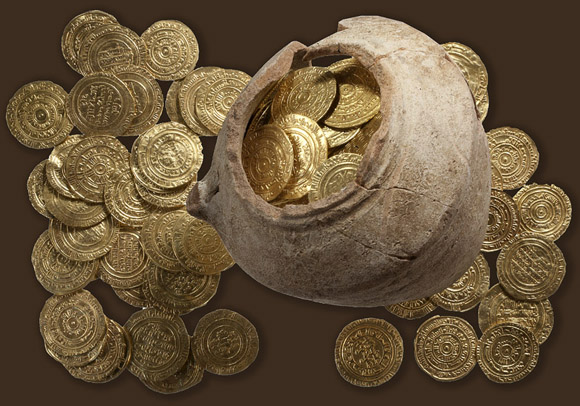
Fig. 19 – A hoard of Fatimid and Zirid gold dinars and fractions from the castle (Area F).
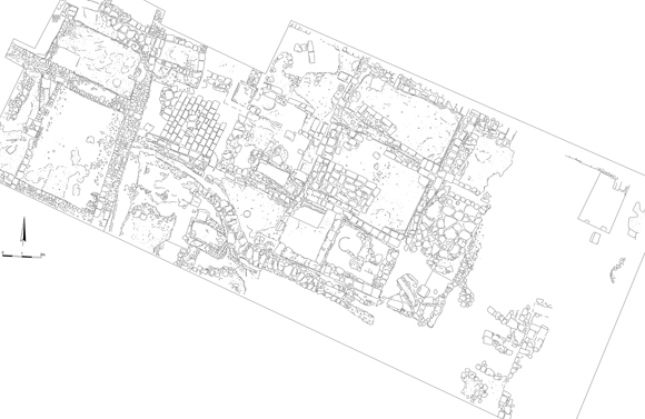
In Area R, located in the center of the medieval walled town and excavated in 2006, 2009, and 2010, we uncovered an industrial installation of the Byzantine period that was later incorporated into a dwelling of the late Crusader period (13th century CE). This Crusader-period dwelling has been partially uncovered. Its original foundations comprised three rooms: two on the south and one on the eastern part of the excavated area. The two rooms on the south were found abandoned, with complete as well as restorable pottery and glass vessels on their floors (Fig. 20). The room on the eastern side had probably formed part of the courtyard and it revealed paved working surfaces and an intact clay oven (tabun). The upper layers that we excavated in the Byzantine installation, and which were later used as a refuse pit, included pottery and glass vessels of the Crusader period (12th–13th century CE), while the lower layers included pottery and glass vessels of the Early Islamic period (8th–11th century CE). The only physical connection between the later building and the installation, however, can be connected to the mid-13th century CE, based on the pottery and glass evidence. It is likely that the building was abandoned in the context of the Mamluk conquest of the site (March-April 1265).
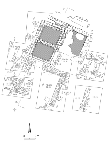 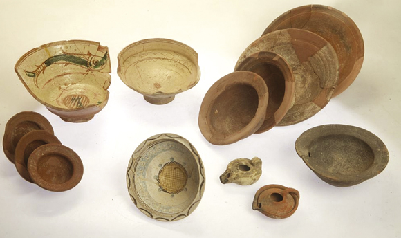 |
Fig. 20 – Plan of the architectural remains in Area R (on left), an assemblage of pottery vessels from the late Crusader building floors (on right)
Additional Crusader-period dwellings were also unearthed in Areas T and U after being mapped in a geo-magnetic survey. Area T, located in relative proximity to the southern part of the walled town, was excavated in 2012, 2013, 2014, 2015, and 2016. The plans of these buildings reveal a central courtyard surrounded by rooms of different sizes and functions, and their history of occupation goes back to the Early Islamic period (Fig. 21).
|
Fig. 21 – Dwellings of the Crusader period (Area T), photo (on left), plan (on right) |
Excavation in Area U (located in relative proximity to the western town fortifications) took place from 2012 to 2013, and provided evidence of continuous inhabitation from the Byzantine to the Crusader period (Fig. 22). Floors of kurkar ashlars and a rudimentary white mosaic with reddish panels, as well as a collection of finds, attest to the area’s use in the Byzantine period. During the Early Islamic period a rectangular enclosure divided by several partition walls was erected, and the finds there attest to a domestic character. Noteworthy is a vaulted cesspit close to its northeastern corner, juxtaposed to a built sunken chamber. Following the Crusader occupation early in the 12th century a few architectural changes were made to the complex, especially in its eastern part. Scorch marks and intentional fills of rubble and soil may suggest its destruction by the Ayyubids in 1187 and its rebuilding by the Crusaders in the early-mid-13th century. This is attested to by the apparent levelling of the area’s eastern part, where a retaining wall set in opus spicatum was discovered. Occupational fills in the area’s upper level revealed 13th-century finds. Some World War I militaria were also found in the area, attesting to its use during the historically documented stay of British forces at the site from December 1917 to September 1918.
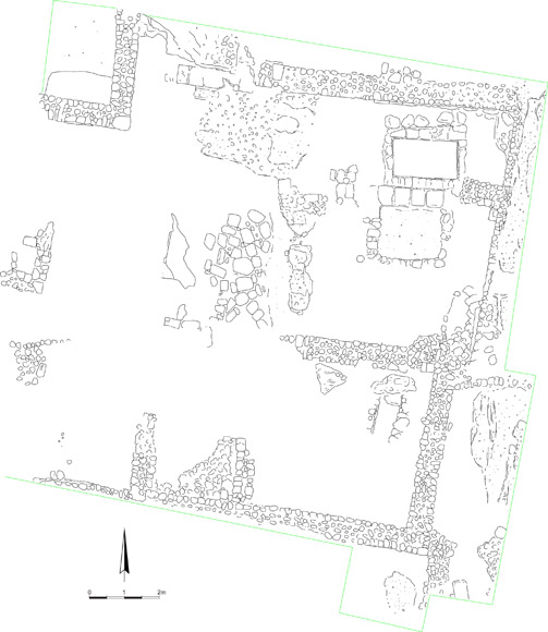 |
Fig. 22 – Plan of the architectural remains in Area U, photo (on left), plan (on right)
In Area L, located in the southwestern corner tower of the Crusader town fortifications and excavated in 2010, we uncovered the fortification system of the Crusader town on top of that of the Early Islamic town; both of which were constructed upon Byzantine architectural remains (Fig. 23).
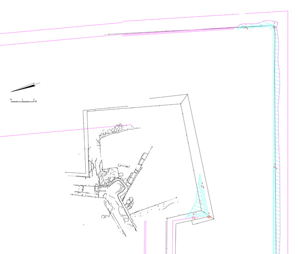 |
Fig. 23 – Plan of the architectural remains in Area L, photo (on left), plan (on right)
In Area M, in the southern part of the site, outside the walled town area, excavated in 2006 and 2009, we uncovered a large 6th–7th century CE refuse pit, beneath which a hoard of 4th–5th century CE bronze coins was revealed.
In Area N1, ca. 10 m northeast of Area N, excavated in 2017, the remains of yet another dismantled glass furnace have been unearthed, revealing a considerable amount of raw glass production debris.
In Area S, located at the far western end of the site adjacent to the western section of the Early Islamic town wall and excavated in 2010, we unearthed both the remains of the wall and its foundations. Excavations also uncovered a casemate of the wall whose floor was partially paved with blocks of stones. The floor was dated based on the pottery evidence to the Early Islamic period (8th–9th century CE). Earlier remains (namely industrial installations) dated to the Late Byzantine period, which had occupied the area prior to the foundation of the Early Islamic fortification system, were also discovered. These were accompanied by a modest assemblage of decorative architectural items dated to the Late Byzantine period found out of context in the excavated area. These items point to the possibility that the area to its east, which is much higher, had served as a public building or a manor house.
In Area W, in the western part of the site, excavated in 2012, presented a positive trial for the site’s geo-magnetic survey. We revealed a Late Byzantine / Early Islamic period silo built of perpendicular (header) blocks (1.8 m inner diameter). At a certain stage, probably in the 7th century, the silo went out of use and became a dumping facility where organic and non-organic refuse was discarded.
Works in additional areas were carried out in 2012 with the financial backing of the Israel Nature and Parks Authority in the context of a planned disabled access route around the Apollonia National Park:
In Area P1 (an extension of Area P, excavated in the 2003, 2004, and 2006 seasons), segments of plastered wall structures, apparently of the Late Byzantine and Early Islamic period, built (in part) upon an earlier mosaic floor, were uncovered under a thick layer of whitish mortar-like uneven paving close to the topsoil. The paving seems to have been laid in the context of the defense works against the Mamluk attack, as it is located inside and opposite the 21 m long breach in the medieval town wall. Among the findings recovered were several Crusader/Mamluk period arrowheads identical to those recovered in the castle, and a few lamps and coins belonging to the same time frame (like those found in Area P). The area’s upper level thus provides a material manifestation of the Crusader defenders’ attempt to prevent the Mamluk forces from taking the town.
In Area P2, which is a 5 x 5 m square dug across the moat (on its southern side) opposite Area P1, although we unearthed the outer wall of the Crusader-period moat to its full thickness (1.1 m), there were no finds of any kind.
In Area Q, which is located across the Crusader castle’s moat where the remains of the through bridge were recorded, the dig sought to uncover the main town-street that led to the castle. Excavations in this area were followed by a geo-radar survey, which revealed no architectural remains other than a few scattered building stones and patches of packed-earth floor. The Crusader-period street level appears to have been destroyed during development of the Israel Military Industries factory.
In Area X, which is located in the center of the walled town and on the current visitors’ route, we cleaned an intact Early Islamic/Late Byzantine-period cistern measuring ca. 4 x 2 m and 4 m deep. The cistern features two original openings, and it seems to have served a dwelling that still awaits excavation.
During the 2014 season an important discovery was made on the mosaic floor excavated earlier in Area P1. This was a bi-lingual Greek-Aramaic inscription probably originally featuring in the hall of a Samaritan synagogue of the Early Byzantine period. The inscription reads in Greek: “One only god / who helps / Gadiona / and Iulianus / and all who deserve it”; while the Aramaic (written in Samaritan script) can be translated as “(made it from his) possession in this place.” (Fig. 24).
Fig. 24 – A bi-lingual inscription (Area P1)
The 2012 and 2013 seasons of excavations of the site’s eastern outskirts, namely the site’s immediate hinterland, were confined to several areas of excavations whose main discoveries can be summarized as follows:
In Area AA1 several plastered installations were exposed, including round and square collecting vats paved with mosaic (Fig. 25). The vats were part of a winepress in which two construction phases from the Byzantine period have been discerned. In the early phase, the press comprised two small, round collecting vats, while in the later phase it was expanded to hold three large vats, one rounded and the other two square. The walls of the winepress were constructed of medium-sized kurkar stones bonded with a grayish-white mortar. The winepress originally had a treading floor close to the surface level, but this was apparently destroyed by later activity. In the southern part of the area several sections of a work surface built of medium-sized fieldstones, probably dating from the Byzantine or Early Islamic period, were exposed. A single pit grave excavated in the center of the area was aligned in an east–west direction and has been identified as a Bedouin grave.
Fig. 25 – Aerial view of the architectural remains in Area AA1
In Area CC (the largest area of excavations in the site’s eastern outskirts) a huge refuse pit (30 m in diameter) dating to the Late Byzantine period was exposed (Fig. 26). The stratification in the area was uniform: a surface layer of sand covered a layer of potsherds (maximal thickness ca. 1 m) and an underlying layer of alluvium. The pit contained numerous artifacts, including pottery vessels, glass sherds, glass industrial waste, metal objects, and animal bones, as well as more than 200 complete Samaritan oil lamps and more than 700 coins. Although the refuse pit is attributed to the second half of the Byzantine period, parts of it may have been used only for short periods of time within this period. In Area CC2 the excavation yielded a wall built on virgin soil and aligned in a north–south direction. Pottery dating to the Byzantine period was found alongside it.
Fig. 26 – Aerial view of Area CC
UNDERWATER ARCHAEOLOGY
A series of underwater surveys was conducted by E. Grossmann along the sea coast of Apollonia-Arsuf. An underwater inspection team of the Israel Antiquities Authority, headed by E. Galili, also undertook an underwater study there (Fig. 27). Those surveys (carried out in the late 1980s and early 1990s) revealed that Apollonia-Arsuf had possessed two maritime installations: a sheltered, partially built anchorage, and a built facility at the foot of the Crusader castle (rectangular in plan, ca. 80 m long from north to south and 33 m long from east to west). In the sheltered anchorage opposite the fortified town the eastern face of the sandstone reef had been carved and smoothed. Massive conglomerates, large blocks, and ashlar stones were placed on the reef and near it, denoting its role as an artificially improved breakwater. In the sheltered anchorage area a large number of stone anchors of various types were found, as well as sounding leads, and vessels and nails made of bronze. The more impressive finds include fragments of a life-size bronze statue of a male, a bronze statuette of the goddess Minerva, a lead strip (roof-tile?) with Greek letters, and a carved marble vase. Fragments of storage jars and pithoi from the Byzantine period were dominant among the pottery assemblage found in the sheltered anchorage, which also included sherds from the Persian, Hellenistic, Roman, and Byzantine periods. This leads us to concur with Grossman’s conclusion that Apollonia, an industrial center with overseas trade connections, possessed two contemporaneous maritime installations in Byzantine times: one for international trade and another, smaller one, that served the local fishermen and coastal trade. It also indicates that the activity at the anchorage reached its peak in the Byzantine period, that is, during the period when the town of Apollonia-Arsuf (then called Sozousa) reached its peak of territorial expansion. In the eastern part of the anchorage, near the coastline, the remains of a large structure were surveyed, revealing large ashlars, as well as marble and granite columns. From the large quantity of Byzantine storage jar fragments found there, it seems that the building had functioned as a Byzantine maritime storehouse. During Grossmann’s survey of the maritime installation, located at the foot of the Crusader castle, mortar samples from the jetties were subjected to chemical tests and analyzed. The results reveal that although the jetties proper date to the Crusader period, their foundations were laid much earlier, in Byzantine times. Moreover, the foundations of the northern pier seem to have been built in a way similar to the harbor construction method described by Vitruvius (V, 12, 2–6). It is worth noting that the entrance to both maritime installations (the sheltered anchorage and the built facility) opens towards the southwest. The entrance to the anchorage is a natural opening in the sandstone reef, whereas in the built facility it is clearly man-made. This southwest location for the entrances differs radically from the other harbors in Palestine, both past and present, where all the entrances face northwest. This is in order to prevent the south-to-north longshore current (which is prevalent along the Eastern-Mediterranean coast and brings with it sediment from the Nile Delta), from entering the harbors. However, it seems that at Apollonia-Arsuf, the opposite (southwest) location for the entrance was preferred, with the idea of enabling the longshore current to enter the harbor. This can be explained by the geological observation of three nodal points along the Israeli coast, one of them close to Apollonia-Arsuf, where the sea current reverses and runs in a southerly direction. In Antiquity too, the current along this shore most probably ran in the same, reverse, direction, which could explain the unusual choice of both harbor entrances facing south, for the purpose of de-silting by means of natural current action. Alternatively, a more sophisticated rationale for this positioning may have been in order to counteract seaborne sedimentation and thereby enable current-driven de-silting of its basin. In this case, the gaps left across the foundations of the northern pier in the built facility at the foot of the Crusader castle (possibly by the temporary wooden support forms, placed there in accordance with the Vitruvian method), could have served as flushing channels. If so, it is not entirely clear whether the system worked at the time or not.
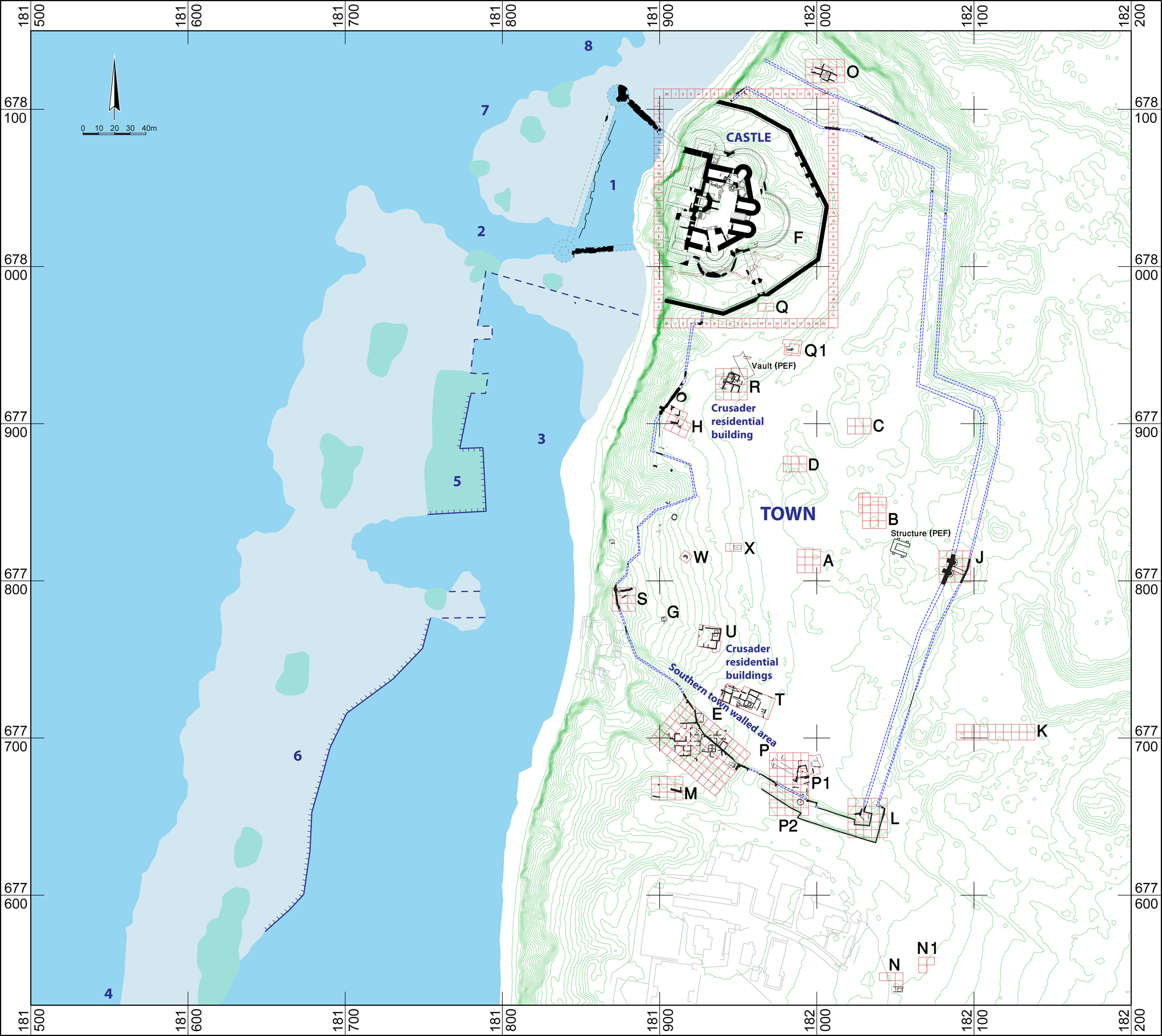
Fig. 27 – Site plan with underwater remains
WORLD WAR I REMAINS
The site of Apollonia-Arsuf played a role during World War I, as on the 22nd–23rd December 1917 a new British army frontline was deployed at the site. First-hand evidence regarding the new frontline and the entrenchment of the troops can be found in the testimony of a soldier who fought at Arsuf and is recorded in E. Thompson’s Crusader’s Coast, London 1929: “Vaults and masonry, that served us for makeshift trenches, are overgrown with datura and scrub; … Will the archaeologist of later ages, examining pillars and tumbled castle, think of us who burrowed in rock-tombs and hid in caves at the cliff root, while the 5,9’s [i.e. 150 mm cannon] rapped on the flowery pastures overhead?” (Thompson 1929: 24–25). Another testimony regarding Arsuf is documented in W.T. Massey’s How Jerusalem Was Won: Being the Record of Allenby’s Campaign in Palestine, London 1919: “At a later date, when digging at Arsuf, these Scots came across some marble columns which had graced a hall when Apollonia was in its heyday. The glory of Apollonia has long vanished, but if in that age of warriors there had been a belief that those marble columns would some day be raised as monuments to commemorate a great operation of war the ancients would have had a special veneration for them. Three of the columns marked the spots where the Scots spanned the river, and it is a pity that they cannot tell the full story to succeeding generations.” (Massey 1919: 235–236). Indeed, these Proconnesian marble columns, which had probably originated in a Byzantine Apollonia/Sozousa, became three memoranda on which inscriptions were carved commemorating the deeds of the British army’s 155th, 156th, and 157th Brigades of the 52nd Division against the Turks, while crossing the Yarkon (Nahr el ‘Auja) River, erected in the three different respective locations of the crossing: at Tell Qudadi (on the north bank of the Yarkon estuary), Kikar Hill (Giv’at Beth HaMitbchahim), and Ramat Gan (at the intersection of Ben Gurion and Aba Hillel Streets), and still visible to this very day.
The material evidence of troops staying and training at the site between late December 1917 and September 1918 is attested to by many finds, among which are ammunition containers, canned food, fragmented helmets, cartridges, musket/shrapnel balls, bullets, etc., along with many uniform buttons. One of the more interesting finds was a still intact kit of morphine ampoules (Fig. 28) found in an upper level of the excavated Area S squares (above). The aerial photographs reveal the emplacements of the troops.
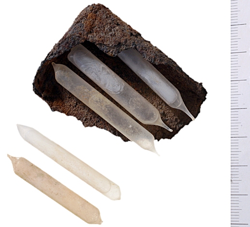
Fig. 28 – A kit of morphine ampules (Area S)
FUTURE GOALS
The Apollonia-Arsuf excavation is an on-going research project. We intend to continue excavations there in order to achieve a better understanding of the site’s economic basis and political affinity, as well as its cultural and economic interactions with other Mediterranean centers during its periods of successive occupation. Mentions of the site in several historical sources from the Roman period, on the one hand, and the limited extent of architectural remains discovered in the excavations, on the other hand, intrigue us to examine further the reasons for its historical importance at the time. As the central site for primary (and probably secondary) glass production on the coastal plain in the Byzantine period, we hope to map all the furnaces discovered at the Apollonia-Arsuf site in order to track the chronological sequences and chemical compositional differences of the various glass finds. We also intend to continue excavating specific elements of the Crusader castle (such as the moat and western halls) in order to acquire a better understanding of its architectural plan. Finally, we wish also to delve deeper into the site’s underwater archaeology. The results of the more recent excavation seasons have already provided a better understanding of the site and, in particular, its social and occupational history of the Early Byzantine and Crusader periods.
EXCAVATION STAFF
Directors
Oren Tal (2007– )
Israel Roll (1977–2006) (in memoriam)
Co-Director
Barbara Scholkmann (2012–2016)
Senior Staff Members
Hagi Yohanan – Field Director (Israeli Team)
Annette Zeischka-Kenzler – Field Director (German Team)
Rafi Lewis – Landscape Archaeology
Hauke Kenzler – Urban-Rural Relations
Tamar Harpak – Registrar
Vardit Shotten-Hallel – Architect
Slava Pirsky / Sergei Alon – Surveyor
Pavel Shrago / Sasha Flit – Photographer
Specialists
Alexander Glick – WWI Militaria
Mark Iserlis – Thin-section Analysis
Ruth Jackson-Tal – Glass
Gaby Bijovsky / Robert Kool – Numismatics
Andrea Orendi – Archaeobotany
Henk Mienis / Oz Ritner – Mollusks
Lidar Sapir-Hen / Miriam Pines / Omri Lernau – Archaeozoology
Arno Patzelt / Martin Waldhör – Geophysical Surveying
Itamar Taxel / Elisabeth Yehuda – Pottery
Mark Iserlis – Thin-section Analysis
Marcio Teixeira Bastos – Thin-section Analysis / Lychnologist
PUBLICATIONS
Monograph
- Roll, I. and Ayalon, E. 1989. Apollonia and Southern Sharon: Model of a Coastal City and its Hinterland. Tel Aviv (Hebrew).
Survey Map
- Gophna, R. and Ayalon, E. 1998. Archaeological Survey of Israel: Map of Herzliyya (69). Jerusalem.
Final Reports
- Roll, I. and Tal, O. 1999. Apollonia-Arsuf: Final Report of the Excavations. Volume I: The Persian and Hellenistic Periods (with Appendices on the Chalcolithic and Iron Age II Remains). Tel Aviv University, Monograph Series of the Institute of Archaeology 16. Tel Aviv.
- Tal, O. 2020. Apollonia-Arsuf: Final Report of the Excavations. Volume II: Excavations Outside the Medieval Town Walls. Tel Aviv University, Monograph Series of the Institute of Archaeology 38. University Park/Tel Aviv.
- Tal, O., ed. Forthcoming. Apollonia-Arsuf: Final Report of the Excavations. Volume III: Excavations Within the Medieval Town Walls. Stratigraphy, Architecture, Pottery and Varied Studies. Tel Aviv University, Monograph Series of the Institute of Archaeology. University Park/Tel Aviv.
Collective Studies
- Roll, I., Tal, O. and Winter, M., eds. 2007. The Encounter of Crusaders and Muslims in Palestine as Reflected in Arsuf, Sayyiduna ‘Ali and Other Coastal Sites. Tel Aviv: HaKibbutz HaMeuchad (Hebrew).
- Tal, O., ed. 2011. The Last Supper at Apollonia: The Final Days of the Crusader Castle in Herzliya. Tel Aviv: Eretz Israel Museum (Bi-lingual Hebrew/English).
Specific Researches
-
Amitai, R. 2005. The Conquest of Arsuf by Baybars: Political and Military Aspects. Mamluk Studies Review 9: 61–83.
-
Amitai-Preiss, N. and Tal, O. 2015. A Lead Bulla from Apollonia-Arsūf with the Place Name Arsūf; Ashkenazi, D. and Tal, O. Appendix: Archaeometallurgical Characteristics of the Bulla. Israel Numismatic Research 10: 191–206.
-
Ashkenazi, D., Golan, O. and Tal, O. 2013. An Archaeometallurgical Study of 13th-Century Arrowheads and Bolts from the Crusader Castle of Arsuf/Arsur. Archaeometry 55/2: 528–548.
-
Ayalon, E., Tal, O. and Yehuda, L. 2013. A Twelfth Century Oil Press Complex at the Crusader Town of Arsur (Apollonia) and the Olive Oil Industry in the Latin Kingdom of Jerusalem. Journal of Eastern Mediterranean Archaeology and Heritage Studies 1/4: 259–291.
-
Birnbaum, R. and Ovadiah, A. 1990. A Greek Inscription from the Early Byzantine Church at Apollonia. Israel Exploration Journal 40: 182–191.
-
Fischer, M. and Tal, O. 2003. A Fourth-Century BCE Attic Marble Totenmahlrelief at Apollonia-Arsuf. Israel Exploration Journal 53: 49–60.
-
Fischer, M., Tambakopoulos, D. and Maniatis, Y. 2018. Recycling of Marble: Apollonia/Sozousa/Arsuf (Israel) as a Case Study. Asmosia 11: 443–456.
-
Freestone, I.C., Jackson-Tal, R.E. and Tal, O. 2008. Raw Glass and the Production of Glass Vessels at Late Byzantine Apollonia-Arsuf, Israel. Journal of Glass Study 50: 67–80.
-
Galili, E., Dahari, U. and Sharvit, J. 1992. Underwater Survey along the Coast of Israel. Excavations and Surveys in Israel 10: 160–166.
-
Galili, E., Dahari, U. and Sharvit, J. 1993. Underwater Survey and Rescue Excavations along the Israeli Coast. International Journal of Nautical Archaeology 22: 61–77.
-
Galili, E., Gorin-Rosen, Y. and Rosen, B. 2015. Mediterranean Coasts, Cargoes of Raw Glass. Ḥadashot Arkheologiyot—Excavations and Surveys in Israel 127.
-
Galor, K., Roll, I. and Tal, O. 2009. Apollonia-Arsuf: Between Past and Future. Near Eastern Archaeology 72/1: 4–27.
-
Grossmann, E. 2001. Maritime Tel Michal and Apollonia: Results of the Underwater Survey 1989–1996. BAR International Series 915. Oxford.
-
Haddad, E., Tal, O., Ajami, M. and Harpak, T. 2015. Apollonia (East). Ḥadashot Arkheologiyot—Excavations and Surveys in Israel 127.
-
Heidemann, S., Nicolle, D. C. and Tal, O. 2021. An Inscribed Ballista Stone from Apollonia-Arsūf, Israel, and Stone-throwing Siege Machines in the Medieval Near East. Journal of Islamic Archaeology 8/2: 239–254.
-
Heidemann, S., Zeischka-Kenzler, A. and Tal, O. 2018. A Magical Rock Crystal Gem from Apollonia-Arsūf, Israel; Ashkenazi, D., Dvir, O. and Tal, O. Appendix: Mineralogical Characterization of the Magical Rock Crystal Gem from Apollonia-Arsūf. Journal of Islamic Archaeology 5/2: 225–239.
-
Jackson-Tal, R.-E. and Tal, O. 2013. Crusader Glass in Context: The Destruction of Arsur (Apollonia-Arsuf, Israel), April 1265. Journal of Glass Study 55: 85–100.
-
Kahane, P. 1951. Rishpon (Apollonia); B. Bulletin of the Department of Antiquities of the State of Israel 3: 42–43 (Hebrew). [For English summary see Perkins 1951, below].
-
Kaplan, E.H. and Kaplan, B. 1975. The Diversity of Late-Byzantine Oil Lamps at Apollonia (=Arsuf). Levant 7: 150–156.
-
Kenzler, H. 2016. Medieval Town Structure of Arsur on the Basis of Non-Invasive Methods: Results of German-Israeli Project Collaboration. Zeitschrift des Deutschen Palästina-Vereins 132/2: 151–174.
-
Kenzler, H. and Zeischka-Kenzler, A. 2015. Reports: German-Israeli Research on the Crusader Town of Arsur and Its Former Lordship. The European Archaeologist 43: 72–79.
-
Kenzler, H. and Zeischka-Kenzler, A. 2021. A Century and Half of Crusader Rule in the Town and Lordship of Arsur. In: Shotten-Hallel, V.R. and Weetch, R., eds. Crusading and Archaeology: Some Archaeological Approaches to the Crusades. Crusades – Subsidia 14. London: 92–115.
-
Khalilieh, S. H. 1999. The Ribât System and Its Role in Coastal Navigation. Journal of the Economic and Social History of the Orient 42: 212–225.
-
Khalilieh, S. H. 2008. The Ribāṭ of Arsūf and the Coastal Defence System in Early Islamic Palestine. Journal of Islamic Studies 19/2: 159–177.
-
Kool, R. and Tal, O. 2015. ‘Underground’ Money in an Outremer Estate: Token Molds and Lead Tokens from Crusader Arsur. Israel Numismatic Research 10: 215–228.
-
Kool, R. and Tal, O. 2020. Another Token Mold and Lead Token from Crusader Arsur (Apollonia). Schweizerische Numismatische Rundschau 98: 215–222.
-
Mirkin, D. 2018. Sailing to the Holy Land: Crusader Ships, Seamnaship, Logistics and Landing Operations. BAR International Series 2904. Oxford.
-
Mirkin, D., Cvikel, D. and Tal, O. 2016. Arsur Castle Maritime Installation (1241–1265 CE). Palestine Exploration Quarterly 148/4: 294–312.
-
Perkins, A. 1951. Archaeological News: The Near East. American Journal of Archaeology 55: 86–87.
-
Orendi, A., Yehuda, E., Zeischka-Kenzler, A. and Tal, O. 2023. Flora in the Latin East: Archaeobotanical Remains from Crusader Arsur. Tel Aviv 50/2: 263–288.
-
Pines, M., Sapir-Hen, L. and Tal, O. 2017. Crusader Diet in Times of War and Peace: Arsur (Israel) as a Case Study. Oxford Journal of Archaeology 36/3: 307–328.
-
Pines, M., Sapir-Hen, L. and Tal, O. 2017. Consumption and Disposal Practices in the Southern Levant in Late Antiquity: Animal Bones from ’Aπολλωνία/Σώζουσα’s Hinterland as a Case Study. Zeitschrift des Deutschen Palästina-Vereins 133/2: 186–204.
-
Raphael, K. and Tepper, Y. 2005. The Archaeological Evidence from the Mamluk Siege of Arsuf. Mamluk Studies Review 9: 85–100.
-
Roll, I. 1996. Medieval Apollonia-Arsuf: A Fortified Coastal Town in the Levant of the Early Muslim and Crusader Periods. In: Balard, M., ed. Autour de la première Croisade. Actes du Colloque de la Society for the Study of the Crusades and the Latin East (Clermont-Ferrand, 22–25 juin 1995). Paris: 597–606.
-
Roll, I. 2006. Apollonia-Arsuf: A Coastal Town of the Eastern Mediterranean Shore in Early Christian and Byzantine Times. In: Harreither, R. et al. Akten des XIV Internationalen Kongresses für Christlische Archäologie. Wien: 681–685.
-
Roll, I. 2008. Der frühislamische Basar und die Kreuzfahrerburg in Apollonia-Arsuf. In: Piana, M., ed. Burgen und Städte der Kreuzzugszeit. Petersberg: 252–262.
-
Roll, I. and Arubas, B. 2006. Le château d’Arsur: Forteresse côtière pentagonale du type concentrique du milieu du XIIIe siècle. Bulletin Monumental 164/1: 67–81.
-
Roll, I. and Ayalon, E. 1987. The Market Street at Apollonia-Arsuf. Bulletin of the American Schools of Oriental Research 267: 61–76.
-
Roll, I. et al. 2000. Apollonia-Arsuf during the Crusader Period in Light of New Discoveries. Qadmoniot 119: 18–31 (Hebrew).
-
Roll, I. and Tal, O. 2008. A Villa of the Early Roman Period at Apollonia-Arsuf. Israel Exploration Journal 58: 132–149.
-
Roll, I. and Tal, O. 2009. A New Greek Inscription from Byzantine Apollonia-Arsuf / Sozousa: A Reassessment of the Heis Theos Monos Inscriptions of Palestine. Scripta Classica Israelica 28: 139–147.
-
Rudin, T., Tal, O., Taxel I. and Feldstein, A. 2018. Two Burial Caves at Kefar Shemaryahu: More on Samaritan and Christian Interactions in the Byzantine-Period Central Coastal Plain. Liber Annuus 68: 269–302.
-
Sapir-Hen, L., Pines, M. and Tal, O. 2014. Animal Economy and Social Diversity in Byzantine Apollonia/ Sozousa. Levant 46/3: 371–381.
-
Schoueri, K.G. and Teixeira-Bastos, M. 2021. A Theoretical Framework for Informal 3D Rendered Analysis of the Roman Lararium from Apollonia. Open Archaeology 7/1: 499–518.
-
Shachar, I. 2000. Greek Colonization and the Eponymous Apollo. Mediterranean Historical Review 15/2: 1–26.
-
Shotten-Hallel, V., Yohanan, H., Harpak, T. and Tal, O. 2021. Apollonia, Arsur Castle. Ḥadashot Arkheologiyot—Excavations and Surveys in Israel 133.
-
Shotten-Hallel, V.R., Yohanan, H. and Tal, O. 2021. The Castle Chapel of Arsur – New Evidence for Its Location and Architecture. In: Shotten-Hallel, V.R. and Weetch, R., eds. Crusading and Archaeology: Some Archaeological Approaches to the Crusades. Crusades – Subsidia 14. London: 369–400.
-
Shotten-Hallel, V., Ashkenazi, D. and Tal, O. 2022. Archaeometallurgical Analysis of Thirteenth-Century Bronze and Iron Construction Implements from the Walls of the Frankish Castle at Arsuf/Arsur. Metallography, Microstructure, and Analysis 11: 255–280.
-
Shotten-Hallel, V.R., Yohanan, H., Fischer, M. and Tal, O. 2023. Et domus sua cuique est tutissimum refugium: Jean II of Ibelin, Arsur Castle and the Hospitallers. In: Khamisy, R.G., Lewis, R. and Shotten-Hallel, V.R., eds. Exploring Outremer Volume II: Studies in Crusader Archaeology in Honour of Adrian J. Boas. Crusades – Subsidia. London: 74–106.
-
Sussman, V. 1983. The Samaritan Oil Lamps from Apollonia-Arsuf. Tel Aviv 10: 71–96.
-
Tal, O. 1995. Roman-Byzantine Cemeteries and Tombs around Apollonia. Tel Aviv 22: 107–120.
-
Tal, O. 2000. Some Notes on the Settlement Patterns of the Persian Period Southern Sharon Plain in Light of Recent Excavations at Apollonia-Arsuf. Transeuphratène 19: 115–125.
-
Tal, O. 2009. A Portable Sundial from Byzantine Apollonia-Arsuf / Sozousa? Semitica et Classica 2: 91–96.
-
Tal, O. 2009. A Winepress at Apollonia-Arsuf: More Evidence on the Samaritan Presence in Roman-Byzantine Southern Sharon. Liber Annuus 59: 319–342.
-
Tal, O. 2010. Apollonia-Arsuf 2006, 2009. Israel Exploration Journal 60: 107–114.
-
Tal, O. 2012. A Portable Sundial from Apollonia-Arsuf Revisited. Semitica et Classica 5: 245–248.
-
Tal, O. 2015. A Bilingual Greek-Samaritan Inscription from Apollonia-Arsuf/Sozousa: Yet More Evidence of the Use of Heis Theos Monos Formula Inscriptions among the Samaritans. Zeitschrift für Papyrologie und Epigraphik 194: 169–175.
-
Tal, O. 2019. Apollonia/Sozousa: Its Immediate Hinterland in Byzantine Times. In: Lichtenberger, A., Tal, O. and Weiss, Z., eds. Judaea/Palaestina and Arabia: Cities and Hinterlands in Roman and Byzantine Times. Volume 44, Panel 8.6; Proceedings of the 19th International Congress of Classical Archaeology Cologne/Bonn, 22 – 26 May 2018. Archaeology and Economy in the Ancient World, edited by M. Bentz and M. Heinzelmann. Heidelberg: 67–80.
-
Tal, O. 2020. A Samaritan Synagogue of the Byzantine Period at Apollonia-Arsuf/Sozousa? Religions 11: 127. [DOI: 10.3390/rel11030127]
-
Tal, O. and Baidoun, I. 2010. A Hoard of Mamluk, Ottoman and Venetian Coins (Fifteenth to Sixteenth Centuries) from Apollonia-Arsuf, Israel. Numismatic Chronicle 170: 484–493.
-
Tal, O., Jackson-Tal, R.E. and Freestone, I.C. 2004. New Evidence of the Production of Raw Glass at Late Byzantine Apollonia-Arsuf, Israel. Journal of Glass Study 46: 51–66.
-
Tal, O., Kool, R. and Baidoun, I. 2013. A Hoard Twice Buried? Fatimid Gold from Thirteenth Century Crusader Arsur (Apollonia-Arsuf). Numismatic Chronicle 173: 261–292.
-
Tal, O. and Roll, I. 2018. The Roman Villa at Apollonia (Israel). In: Métraux, G. P. R. and Marzano, A., eds. The Roman Villa in the Mediterranean Basin. Cambridge: 308–316.
-
Tal, O. and Taxel, I. 2012. Socio-Political and Economic Aspects of Refuse Disposal in Late Byzantine and Early Islamic Palestine. In: Matthews, R., Curtis, J., et al. Proceedings of the 7th International Congress on the Archaeology of the Ancient Near East, 12–16, April 2010. Wiesbaden: 497–518.
-
Tal, O. and Taxel, I. 2017. More Than Trash – Cultic Use of Pottery Lamps Found in Late Antique Dumps: Apollonia (Sozousa) as a Test Case. In: Tal, O. and Weiss, Z., eds. Expressions of Cult in the Southern Levant in the Greco-Roman Period: Manifestations in Text and Material Culture. Contextualizing the Sacred 6. Turnhout: 181–193.
-
Tal, O. and Taxel, I. 2021. Arsuf (Apollonia, Palestine) Post-Occupational History: The Biography of a Desolated Site. International Journal of Historical Archaeology 25.
-
Tal, O., Taxel, I. and Zeischka-Kenzler, A. 2018. A Basmala-Inscribed Jug from Arsur's Mamluk Destruction of AD 1265: The Religious Manifestation of a Christian-Used Table Vessel? Journal of Near Eastern Studies 77/1: 91–98.
-
Tal, O. and Teixeira Bastos, M. 2012. Intentionally Broken Discus Lamps from Roman Apollonia: A New Interpretation. Tel Aviv 39/1: 105–115.
-
Tal, O. and Teixeira Bastos, M. 2015. More on the Intentionally Broken Discus Lamps from Roman Palestine: Mutilation and Its Symbolic Meaning. In: Blömer, M., Lichtenberger, A. and Raja, R., eds. Religious Identities in the Levant from Alexander to Muhammed: Continuity and Change. Contextualizing the Sacred 4. Turnhout: 345–368.
-
Tal, O. and Yohanan, H. 2025. Apollonia. Ḥadashot Arkheologiyot—Excavations and Surveys in Israel 137.
-
Tal, O., Yohanan, H., Ajami, M. and Jackson-Tal, R. Apollonia. 2017. Ḥadashot Arkheologiyot—Excavations and Surveys in Israel 129.
-
Tal, O., Yohanan, H. and Harpak, T. 2025. Apollonia, Arsur Castle. Ḥadashot Arkheologiyot—Excavations and Surveys in Israel 137.
-
Teixeira Bastos, M., Bouzaglou, L., Goren, Y. and Tal, O. 2025. From Hinterland Production to Market Dynamics: Petrographic Study of Roman Discus Lamps and Their Trade in the Southern Levant. Tel Aviv 52/2: 274–297.
-
Ting, C., Taxel, I., Merkel, S. and Tal, O. 2025. The Glaze is Less Opaque on the Other Side: The Development of Egyptian and Southern Levantine Glazed Ceramic Production from the Early Islamic to Crusader Periods. Journal of Archaeological Science 179: 106255.
-
Wexler, L. and Gilboa, G. 1994. A Signet Ring from the Apollonia-Arsuf Excavations. Tel Aviv 21: 288–291.
-
Wexler, L. and Gilboa, G. 1996. Oil Lamps of the Roman Period from Apollonia-Arsuf. Tel Aviv 23: 115–131.
-
Zeischka-Kenzler, A., Yohanan, H., Kenzler, H., Harpak, T., Scholkmann, B. and Tal, O. 2018. Apollonia. Ḥadashot Arkheologiyot—Excavations and Surveys in Israel 130.
-
Zeischka-Kenzler, A., Yohanan, H., Kenzler, H., Harpak, T., Yehuda, E., Scholkmann, B. and Tal, O. 2021. The Crusader Town of Arsur by the Sea: A German-Israeli Collaborative Project (2012–2016). In: Kamlah, J. and Lichtenberger, A., eds. The Mediterranean Sea and the Southern Levant: Archaeological and Historical Perspectives from the Bronze Age to Medieval Times. Abhandlungen des Deutschen Palästina-Vereins 48. Wiesbaden: 337–360.
Last Updated – December 17, 2025

